CALJET/NORPEX: California Land-Falling Jets Experiment / NORth Pacific EXperiment (CALJET)
Observation of prefontal low-level jets (LLJ) contained within extratropical cyclones are a key factor to improving cyclone forecasts and providing more accurate emergency warnings. Land falling cyclones cause extensive damage as they come ashore on the US west coast by producing more than 8 inches of rain in a 24 hour period accompanied by surface winds exceeding 50 m/s. The accurate forecast of these events needed to alert the public, military and emergency services are often off by as much as several hours and 300 km. The need for improvements in this type of forecast is reflected in the objectives of the National Weather Service and the USWRP. These views are also supported by recommendations of operational weather forecasters from NOAA and the military.
A key element of these severe storms is the prefrontal low-level jet (LLJ). This jet can cause extreme coastal rains when it encounters mountains and damaging coastal winds can be created by low-level blocking or mountain wave behavior. Operational forecasters have long used the LLJ’s strength, position and moisture content to help predict precipitation rates and coastal winds. Significant errors in these key parameters occur due to the limited amount of data available offshore and aloft along the coast.
Adjoint techniques have been used to identify limited regions where additional data and improved observation of the LLJ could help forecasts downstream. These approaches suggest that improved knowledge of the position and strength of the LLJ offshore, 0-18 hours before landfall could allow mesoscale numerical models to better predict the location and intensity of flooding rains and damaging winds. Predictions of the overall motion and development of the entire cyclone may also improve with the more accurate observation of the LLJ
NOAA
Related Websites
Publications
-
Langland, R. H.; Toth, Z.; Gelaro, R.; Szunyogh, I.; Shapiro, M. A.; Majumdar, S. J.; Morss, R. E.; Rohaly, G. D.; Velden, C.; Bond, N., and Bishops, C. H. The North Pacific Experiment (NORPEX-98): Targeted observations for improved North American weather forecasts. Bulletin of the American Meteorological Society v.80, no.7, 1999, pp1363-1384.
-
Ralph, F. M.; Persson, P. O. G.; Reynolds, D.; Nuss, W.; Miller, D.; Schmidt, J. ; Jorgensen, D.; Wilczak, J.; Neiman, P. ; Bao, J. W.; Kingsmill, D.; Toth, Z.; Velden, C.; White, A.; King, C., and Wurman, J. The California Land-falling Jets experiment (CALJET): Objectives and design of a coastal atmosphere-ocean observing system deployed during a strong El Nino. Symposium on Integrated Observing Systems, 3rd, Dallas, TX, 10-15 January 1999 (preprints). Boston, MA, American Meteorological Society, 1999, pp78-81. Reprint #2522.
-
Xiao, Q.; Zou, X.; Shapiro, M.; Velden, C., and Pondeca, M. Prediction of a NORPEX oceanic cyclone: Impact of initial conditions incorporating GMS water vapor winds and Total Ozone Mapping Spectrometer (TOMS) data. Conference on Satellite Meteorology and Oceanography, 10th, Long Beach, CA, 9-14 January 2000 (preprints). Boston, MA, American Meteorological Society, 2000, pp14-15. Reprint #2650.
-
Xiao, Qingnong; Zou, X.; Pondeca, M.; Shapiro, M. A., and Velden, C. Impact of GMS-5 and GOES-9 satellite-derived winds on the prediction of a NORPEX extratropical cyclone. Monthly Weather Review v.130, no.3, 2002, pp507-528. Reprint #3149.
-
Xiao, Qingnong; Zou, Xiaolei; Pondeca, Mamuel, and Velden, Chris S. Impact of GMS-5 and GOES-9 satellite-derived winds on the prediction of a NORPEX extratropical cyclone. Conference on Weather Analysis and Forecasting, 18th and Conference on Numerical Weather Prediction, 14th, Fort Lauderdale, FL, 30 July-2 August 2001 (preprints). Boston, MA, American Meteorological Society, 2001, ppPaper P4.6. Reprint #3873.
Images
-
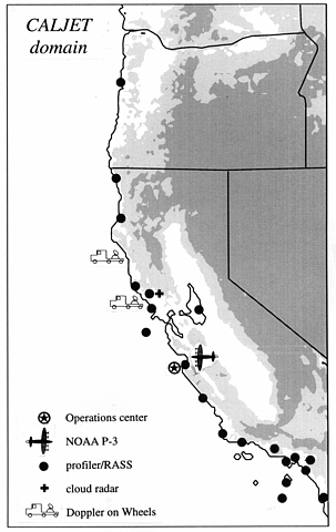
A map of CALJET’s coastal domain showing key observing systems deployed for the experiment. Coastal and drifting buoys are not shown. Topography is shown by shading: light gray is 0.3 – 1.0 km MSL, and dark gray is >1.0 km MSL.
NOAA